Cleveland - GeographiC Definitions
Exactly what are the boundaries and population of Cleveland? Depending on the use and the speaker, geographic differences exist with respect to “Cleveland”. This page seeks to add clarity to the range of terms and the boundaries of these terms that are in common use. “Cleveland” itself may refer to any of the following. The population data below, for the geographic definitions, are based on US Census Bureau 2024 Estimates.
1. City of Cleveland. The municipal corporation of Cleveland, also referred to “Cleveland Proper”. This geography is the core of all other terms centered on Cleveland, such as “Greater Cleveland” or “Cleveland MSA”. and represents the economic, financial, medical, social, educational, legal, innovation, and cultural center of the region.
2. “Greater Cleveland”. Generally, the City of Cleveland and surrounding area. Depending on the speaker, this geography may be
a.) Cuyahoga County (the county in which Cleveland presides). Population: 1,240,594.
b.) Cuyahoga County and the six outer counties: Lorain, Medina, Summit, Portage, Geauga, and Lake. Population: 2,777,180.
c.) Cuyahoga and the six outer counties ( Lorain, Medina, Summit, Portage, Geauga, and Lake) and also some additional counties such as Ashtabula to the northeast, Erie to the west, and Stark to the south, amongst others. Population: 2.8M - 4.0M, depending on which areas are included.
d.) Cuyahoga County and the adjacent suburbs such as Avon Lake in Lorain County, Brunswick in Medina County, Aurora in Portage County, or Willowick in Lake County. Population: somewhere between 1.2M and 2.8M, depending on which areas are included.
3. Metropolitan Cleveland. Similar to “Greater Cleveland”, there is no official or governmental definition, and its area of coverage may be defined the same as is Greater Cleveland, above. Here, at the Center for Cleveland, we officially define “Metropolitan Cleveland” as the following eight counties: Cuyahoga (of which Cleveland is the center) and the seven outer counties: Lorain, Medina, Summit, Portage, Geauga, Lake, and Ashtabula. In this definition, “Metropolitan Cleveland” is the full combined areas of the US-government defined Cleveland MSA and Akron MSA. Population: 2,874,086.
4. “Northeast Ohio”. This term is almost exclusively used to represent an area other than Northeast Ohio. It is mostly used by people in Cleveland/Greater Cleveland—-including people, businesses, even the media—as a synonym for “Greater Cleveland” meaning the geographies in #2, above—-and oftentimes used to mean only Cuyahoga County. “Northeast Ohio”—the northeast part of the state—is actually the area containing Cleveland, Canton, Youngstown, and Conneaut—however it is incessantly used incorrectly, and almost never is used to refer to this broader geography.
5. Cleveland Metropolitan Statistical Area (MSA). MSA boundaries are set by the Census Bureau applying rules established by the US Office of Management & Budget and were meant to define an inter-dependent urban geographic area. However, the counties included in the Cleveland MSA are not an accurate depiction of such an area. An MSA is supposed to include all the suburbs of a city that are tied to that city. But MSAs are also comprised of full counties. In the case of Cleveland, some Cleveland suburbs, such as Twinsburg or Aurora are not counted as part of the Cleveland MSA given the presence of Akron, OH, which is given its own MSA. Hence part of the true metropolitan area of Cleveland is “given” to Akron. Hence, the “Cleveland MSA” is neither an accurate depiction of population or physical area. Though Akron is indeed a city in its own right, there are economic, social, and other ties between Akron and Cleveland. Accordingly, a more correct definition of the Cleveland MSA should include Summit and Portage Counties which is currently the two-county “Akron MSA”. The Cleveland MSA is comprised of six counties—Cuyahoga, Lorain, Medina, Geauga, Lake, and Ashtabula, however it is an inaccurate, and thus useless, data point. Using the official Cleveland MSA values makes it impossible to compare Cleveland to other cities in the US because the Cleveland definition and boundaries are flawed. (The US Government defines Cleveland for locality-based pay for government employees very differently and includes one Pennsylvania county; see #10, below.)
6. Cleveland Metropolitan Statistical Area (MSA) if Cleveland were properly defined: Eight counties surrounding Cleveland, that are currently the aggregation of the incorrectly defined Cleveland MSA and the current Akron MSA: Cuyahoga County (wherein Cleveland presides) and the seven outer counties of Lorain, Medina, Summit, Portage, Geauga, Lake, and Ashtabula, Population: 2,874,086.
7. Cleveland-Akron-Canton Combined Statistical Area (CSA): CSA’s are urban agglomerations of adjancent metropolitan and micropolitan statistical areas. The Cleveland-Akron-Canton CSA is comprised of the Cleveland MSA, Akron MSA, Canton–Massillon MSA, Sandusky MSA, and five micropolitan statistical areas: Wooster, New Philadelphia–Dover, Fremont, Norwalk, and Coshocton. Population: 3,750,887.
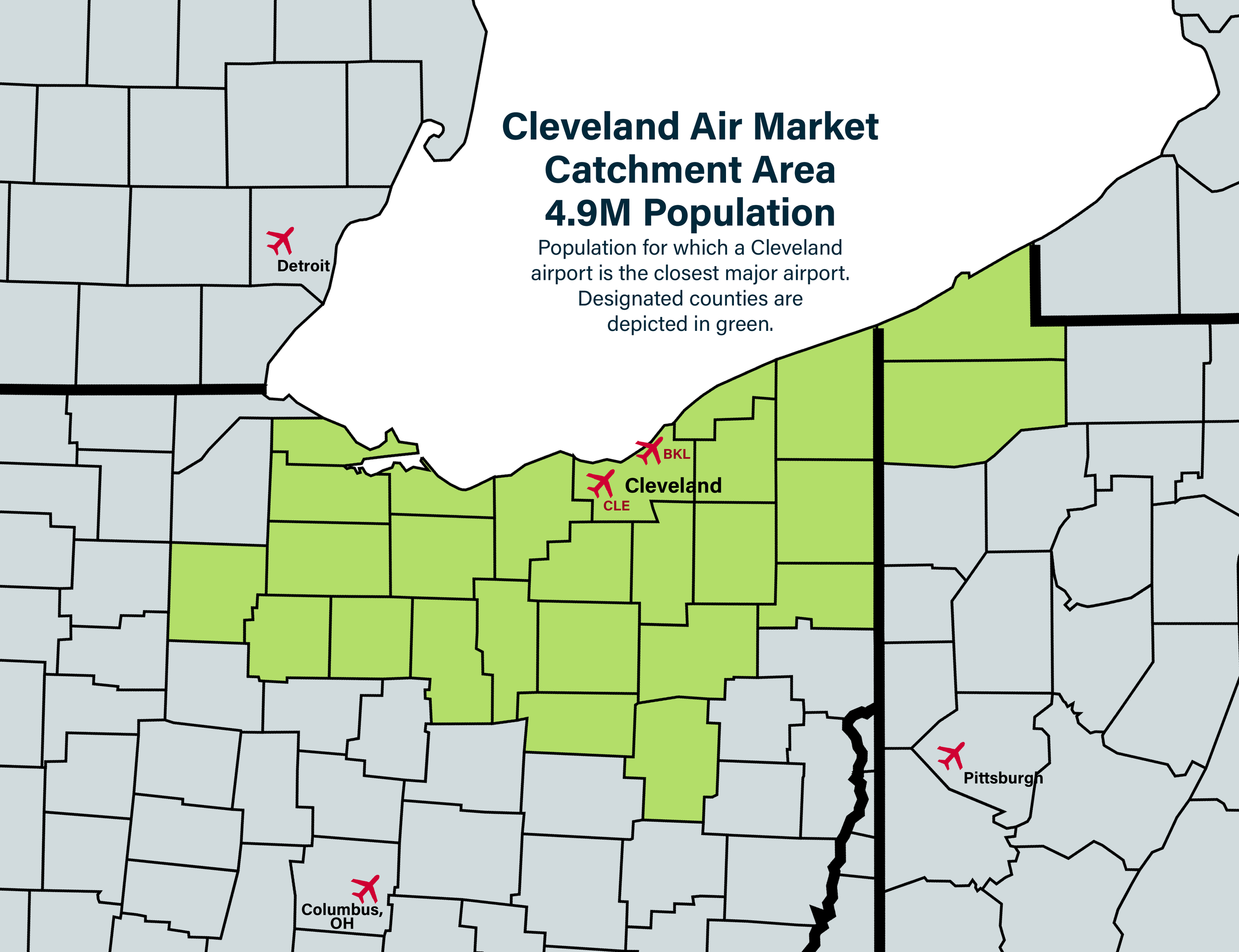
8. Cleveland Air Market or Cleveland Catchment Area: The area in which for the resident population, Cleveland’s primary airport, Cleveland Hopkins International Airport, is the closest major airport serving the area. Population: 4,878,056.
9. Cleveland Media Market - Designated Market Area (DMA). A DMA is established by Nielsen Media Research as a defined geography for television and radio audiences to measure market sizes and identify viewer and listener habits within a geography. Cleveland ranks as the 19th largest media market in the US with 1.6 million households and 3.9 million population.
10. Cleveland - US General Schedule Locality Pay Area. “Cleveland” from the US Government perspective for locality-based pay in 2025 is made of the following counties: Cuyahoga County, OH; Ashland County, OH; Ashtabula County, OH; Carroll County, OH; Columbiana County, OH; Crawford County, OH; Erie County, OH; Geauga County, OH; Harrison County, OH; Holmes County, OH; Huron County, OH; Lake County, OH; Lorain County, OH; Mahoning County, OH; Medina County, OH; Portage County, OH; Richland County, OH; Stark County, OH; Summit County, OH; Trumbull County, OH; Tuscarawas County, OH; Wayne County, OH; and Mercer County, PA.